

TerraScan User Guide
Find Paint Lines
 Find Paint Lines tool is used for automatic paint line digitization on roads. The tool creates 3D line elements based on a loaded and pre-classified point cloud. Points on the road surface should be classified into a separate class by using preferably the Hard surface or Ground classification routine. In the digitization process, another macro may be included that is executed on a temporary copy of the loaded points. It may, for example, classify points with a bright intensity (= points on paint markings) into a separate class that is then used for paint line digitization. This classification is not applied to the loaded points.
The digitization process results in 3D line elements for paint markings. They may be modified with CAD tools or convertied into polygon elements using the Place Paint Line tool.
To find paint lines automatically:
1. Load a point cloud into TerraScan.
2. (Optional) Select linear or polygon elements in order to limit the area for processing.
3. Select Find Paint Lines tool.
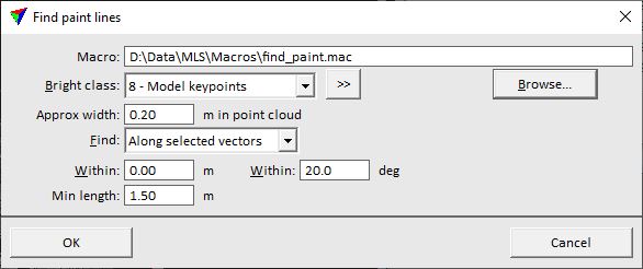
This opens the Find Paint Lines dialog:
3. Define settings and click OK.
This starts the paint line digitization process. The software draws the line elements on the active layer using the active symbology settings of the CAD file.
SETTING |
EFFECT |
|---|---|
Macro |
Macro file that is executed before the paint line detection starts. Click on the Browse button in order to select a macro file in a standard dialog. |
Bright class |
Point class(es) containing points on paint markings and used for paint line digitization. |
|
Opens the Select classes dialog which contains the list of active classes in TerraScan. You can select multiple source classes from the list that are then used in the Bright class field. |
Approx width |
Approximate width of a paint line measured in the point cloud. |
Find |
Defines the area for searching paint lines: •Anywhere - the whole area covered by loaded points. •Inside fence - within a selected polygon or fence element •Along selected vectors - within a given corridor along linear elements. |
Within |
Offset from selected linear elements that defines the corridor for the search. This is active only if Find is set to Along selected vectors. |
Within |
Maximum angular difference between a selected linear element and the paint lines to be detected along this element. This is active only if Find is set to Along selected vectors. |
Min length |
Minimum length of a paint line element. |
