

TerraScan User Guide
Railroad
Not Lite
Railroad routine classifies points which match the elevation pattern of a railroad track.
The conditions for a point that matches the required pattern are:
•A point must have some points in the vicinity which are 0.05 - 0.35 m lower.
•A point can not have any points in the vicinity which would be 0.15 - 2.50 m higher.
•A point can not have any points in the vicinity which would be more than 0.35 m lower.
The routine tries to find points that match the elevation pattern and a given Rail width ± Tolerance setting. Further, it may be supported by an alignment element that can be created using the Place Railroad String tool in TerraScan or any other line string placement tool of the CAD platform.
The alignment element can be used in three different ways:
•None - No alignment is available. The routine tries to find points that match the elevation pattern and have another matching point at Rail width ± Tolerance distance in any direction.
•Track centerline - The alignment follows the centerline between two rails. The routine tries to find points that match the elevation pattern and are at (0.5 * Rail width) ± Tolerance distance from the alignment.
•General direction - The alignment defines the general direction of the railroad. The routine tries to find all points which match the elevation pattern and have another matching point at Rail width ± Tolerance distance. The line between the two points must be close to perpendicular to the alignment direction.
The alignment element(s) must be selected before starting the classification routine.
The routine is suited for ALS data sets with a comparatively low point density. For dense MLS data sets, there are better-suited tools for processing data of railroads in the Railroad toolbox, such as Find Rails tool.
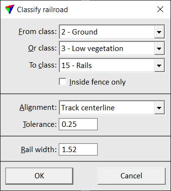
SETTING |
EFFECT |
|---|---|
From class |
Source class(es). |
Or class |
Second source class. |
To class |
Target class. |
Inside fence only |
If on, points inside a fence or selected polygon(s) are classified. |
Alignment |
Usage of an alignment: None, Track centerline, or General direction. |
Tolerance |
Horizontal offset by which the alignment can differ from the true centerline locations. This is active only if Alignment is set to Track centerline. |
Rail width |
Track width, distance from rail center to rail center. The field is followed by another input field that is only active if Alignment is set to None or General direction. The field defines the horizontal offset by which the track width can differ. |