

TerraScan User Guide
Low points
Not Lite
Low points routine classifies single points or groups of points which are lower than other points in the surrounding. It is often used to search for possible error points which are clearly below the ground.
The routine compares the elevation of each point or point group with any other point within a given 2D radius. If the point or point group is clearly lower than any other point, it is classified.
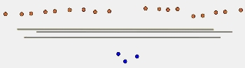
Single low point classification |
Group of low points classification |
The routine finds the lowest point or point group in a data set when it runs once. If there are low points on several elevation levels below the ground, it should be executed several times with different settings. Typically, the routine is included in a macro for ground classification in an airborne laser data set and depending on the amount of error points below the ground, there are two or even more steps for low point classification.
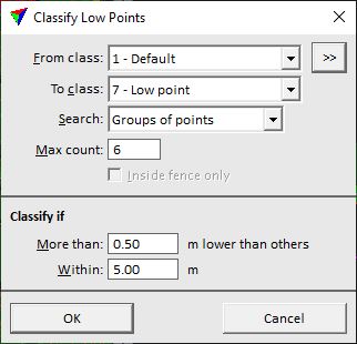
SETTING |
EFFECT |
|---|---|
From class |
Source class(es). |
|
Opens the Select classes dialog which contains the list of active classes in TerraScan. You can select multiple source classes from the list that are then used in the From class field. |
To class |
Target class. |
Search |
Defines the target points: Single points or Groups of points. |
Max count |
Maximum amount of points in a group of low points. This is active only if Search is set to Groups of points. |
Inside fence only |
If on, points inside a fence or selected polygon(s) are classified. |
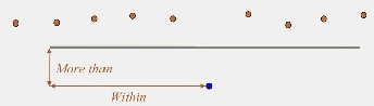
More than |
Minimum height difference between a single point or a group of points and a point in the surrounding. Normally a value between 0.3 - 1.0 m. |
Within |
Size of the 2D search radius. Normally values between 2.0 - 8.0 m. |
