

TerraScan User Guide
By vegetation index
Not Lite
By vegetation index routine classifies groups of points based on a vegetation index computation. The routine requires that color values have been extracted for the points. Color values for laser points can be extracted from raw images or raster attachments loaded into TerraPhoto, or assigned per class by setting values for red, green, and blue channels. See Extract color from images and Assign color to points for corresponding commands in TerraScan.
TerraScan can assign up to 10 color channels for each point. The maximum amount of color channels can only be stored in the TerraScan FastBinary format. LAS 1.4 format and later can store up to 4 color channels, LAS 1.2 format and later up to 3.
There are two methods for computing the vegetation index.
Normalized difference
The method assumes that channel 0 stores red (R) and channel 3 near-infrared (NIR) color values. The normalized difference value is computed with the following equation:
ND = (NIR - R) / (NIR + R) -1 <= ND <= +1
Visual band difference
The method assumes that channel 0 stores red (R), channel 1 green (G), and channel 2 blue (B) color values. The visual band difference value is computed with the following equation:
VBD = (2*G - R - B) / (2*G + R + B) -1 <= VBD <= +1
The routine is well suited for separating points on vegetation from non-vegetation points. You can check how well the vegetation index computation separates vegetation from non-vegetation points by displaying points by vegetation index. The larger the difference value, the more likely a point is representing vegetation.
The routine further requires that points have been assigned to groups using the Assign groups commands or corresponding macro actions.
SETTING |
EFFECT |
|---|---|
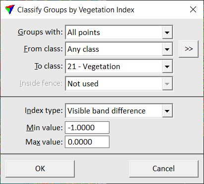
Groups with |
Determines which groups are classified: •One or more points - groups with one or more points in the source class. •Majority of points - groups with the majority of points in the source class. •All points - groups with all points in the source class. |
From class |
Source class(es). |
|
Opens the Select classes dialog which contains the list of active classes in TerraScan. You can select multiple source classes from the list that are then used in the From class field. |
To class |
Target class. |
Inside fence |
Determines how a fence or selected polygon(s) effect the classification: •Not used - fence or selected polygons are ignored. •One or more points - groups are classified if one or more points are inside. •Average xy - groups are classified if the average xy point is inside. •Majority of points - groups are classified if the majority of points is inside. •All points - groups are classified if all points are inside. |
Index type |
Method of vegetation index computation: Normalized difference or Visual band difference. |
Min value |
Minimum difference value to be classified. |
Max value |
Maximum difference value to be classified. |
