

TerraPhoto User Guide
Retile images
Retile images command creates new images from reference files using a new tile array. This requires the definition of tiles using for example Place tile array command in TerraPhoto or any other tool for digitizing rectangles. The new images can be named automatically or by utilizing text elements placed inside each tile.
During the retile process, another image format, pixel size, or clip boundaries can be applied to the new images. In addition, the process can use vector elements on a specific CAD file level and "burn" these elements into the new image.
The rotation of the images can be orthonormal or defined by a line element. The line element represents the left-right axis for the new images and must be drawn into the CAD file before starting the retiling process. Rotated images can not be saved with internal georeferencing information.
To retile images:
1. Select tiles and (optional) text elements inside each tile using any Selection tool of the CAD platform.
2. (Optional) Select a line element that defines the rotation for the new images.
3. (Optional) Select reference images to be used for retiling images.
4. Select Retile images command from the Utility pulldown menu.
This opens the Retile Images dialog:
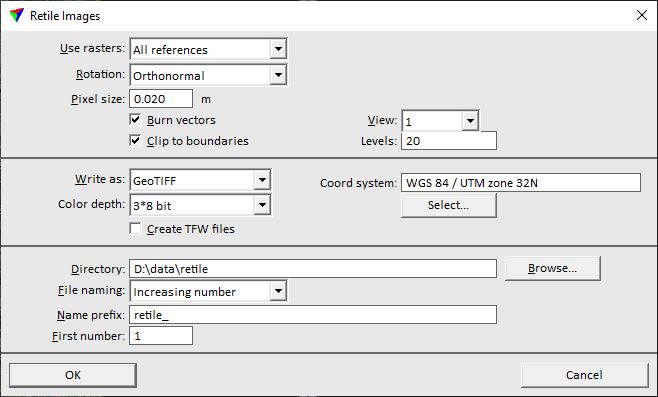
5. Select settings and click OK.
This starts the retiling process. An information dialog show the number of created image.
SETTING |
EFFECT |
|---|---|
Use rasters |
Reference images used for retiling: All references or Selected only. |
Rotation |
Rotation of the new images: •Orthonormal - the north direction points up in the new images. •From selected vectors - a selected line element defines the direction of the left-right axis in the new images. |
Pixel size |
Pixel size of the new images. |
Burn vectors |
If on, all vector elements that are visible in the selected View are drawn into the new images. |
Clip to boundary |
If on, new images are clipped to shape boundaries drawn on the given Levels. |
Write as |
File format of the new images. If the rotation of the images is defined by a selected vector element, only formats JPEG, TIFF, and RawRGB are available. If a TIFF or GeoTIFF file exceeds the size of 4 GB, a BigTIFF file is written. |
Color depth |
Number of channels and color depth of the new images. The number of available channels is determined by the original image, the maximum is 10 channels. |
Create TFW/JGW files |
If on, separate georeferencing files are created for the image formats GeoTIFF, TIFF, and JPEG. |
Target Ratio |
Compression ratio for the new images. This is only active for the formats ECW compressed and JPEG2000. |
Datum/Projection |
Datum and projection information that is written into the image file header. This is only active for formats ECW compressed and JPEG2000. |
Coord system |
Coordinate system information that is written into the image file header. This is only active for format GeoTIFF. |
Directory |
Directory where the new image files are stored. |
File naming |
Defines the naming method for the new image files: •Increasing numbers - files are named by increasing numbers. •Selected names - selected text elements are used to name the files. Requires that a text element is placed inside each tile and selected before the command is started. |
Name prefix |
Text that is added at the beginning of an image name. |
First number |
Number of the first image. This is only active if File naming is set to Increasing numbers. |