

TerraPhoto User Guide
Convert references
Convert references command converts attached reference images into another image format. During the conversion process, a user-defined transformation can be applied to the images. The transformation must be defined in Coordinate transformations / Transformations of the TerraPhoto Settings.
If the transformation is a projection system change, the original rectangular tiles of the images do not remain the same rectangles. The software computes new rectangular tiles by using multiple reference images for each tile.
To convert reference images:
1. (Optional) Select reference images to be converted.
2. Select Convert references command from the Utility pulldown menu.
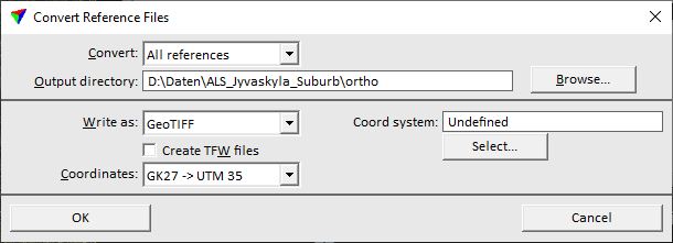
This opens the Convert Reference Files dialog:
3. Select settings and click OK.
This starts the conversion process. A window shows the progress of the process.
Existing image files in the output directory of the conversion that have the same name and format are overwritten without warning.
SETTING |
EFFECT |
|---|---|
Convert |
Reference images that are converted: All references or Selected only. |
Output directory |
Directory for storing the new image files. |
Write as |
File format of the converted images. If a TIFF or GeoTIFF file exceeds the size of 4 GB, a BigTIFF file is written. |
Create TFW/JGW files |
If on, separate georeference files are created for the image formats GeoTIFF, TIFF, and JPEG. |
Target Ratio |
Compression ratio for the new images. This is only active for the formats ECW compressed and JPEG2000. |
Datum/Projection |
Datum and projection information that is written into the image file header. This is only active for formats ECW compressed and JPEG2000. |
Coord system |
Coordinate system information that is written into the image file header. A list of common coordinate system names and EPSG numbers can be opened by clicking on the Select button. This is only active for format GeoTIFF. |
Select |
Opens the Select coordinate system dialog which contains a list of common coordinate system names and their EPSG numbers. The dialog lets you also specify the Unit for writing GeoTIFF files. |
Coordinates |
Transformation applied to the converted images. The transformations must be defined in the TerraPhoto Settings. This is only active if an output format is selected that stores georeferencing information, either internally in the file header (ECW compressed, GeoTIFF, JPEG2000) or externally in an additional file (TIFF + TFW, JPEG + JGW). |
Convert references command can be used to save temporary modifications for reference images permanently into new image files. See command descriptions in Section Edit pulldown menu for information about temporary changes of reference images.