

TerraPhoto User Guide
Import Lynx Survey
Not UAV
Import Lynx Survey command reads information from a Lynx index file and creates a mission file, an image list, and (optional) camera files.
The index file is a text file that contains information about the survey, camera parameters, and images. The file is created by Optech software delivered with the Lynx system. The camera parameters for each camera of the system are converted into a TerraPhoto camera calibration file. The time and positional information for the images are converted into a TerraPhoto image list.
To import a Lynx survey index file:
1. Select Import Lynx Survey command from the Mission pulldown menu.
This opens the Import Lynx survey dialog, a standard dialog for opening files.
2. Select the index file and click Open.
The Import Lynx survey dialog opens:
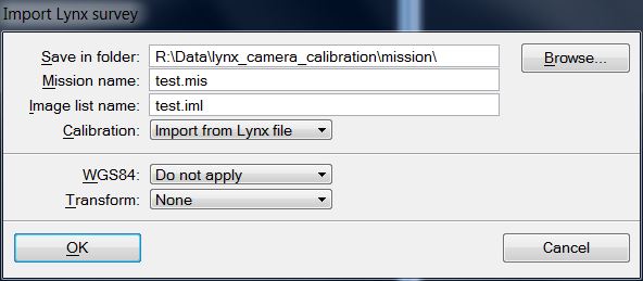
3. Define settings and click OK.
The mission file, an image list file, and possibly camera calibration files are created in the given directory. The camera files are named CAMERA1.CAL and CAMERA2.CAL.
SETTING |
EFFECT |
|---|---|
Save in folder |
Directory that stores the mission file, the image list file, and the camera files. |
Mission name |
Name of the mission file. The extension must be .mis. |
Image list name |
Name of the image list file. The extension must be .iml. |
Calibration |
Method of handling camera calibration files: •Import from Lynx file - the camera calibration information is read from the index file and new TerraPhoto camera files are created. •Use existing cal files - existing TerraPhoto camera files are used and the software does not create new files. The files must be named camera1.cal and camera2.cal. |
WGS84 |
Transformation from WGS84 coordinates to a projection system that is applied to the image list. You can choose from any of the built-in or user-defined projections systems which are set as active in TerraPhoto Settings. |
Transform |
User-defined transformation that is applied to the image list. The list contains transformations defined in Coordinate transformations / Transformations of TerraPhoto Settings. |