

TerraModeler User Guide
Place Elevation Text
Not Lite
 Place Elevation Text tool places a single elevation text. It shows the surface elevation at a given location. The tool can be used to label the difference between two surfaces as well.
Text font, size, and numeric format are determined by leveling point settings in Elevation labels category of the TerraModeler Settings. The settings also define the location of the label relative to the exact elevation point and if a point marker is set at the location of the elevation point. The label is drawn using active level and symbology settings in the CAD file.
To place a single elevation text:
1. Select the Place Elevation Text tool.
This opens the Place Elevation Text dialog:
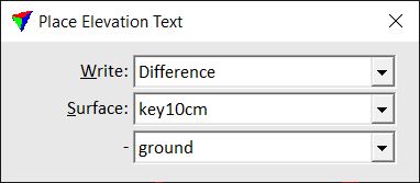
2. Define settings.
3. Move the mouse pointer inside a view.
A preview of the label at the mouse pointer location is dynamically displayed.
4. Confirm the elevation text location with a data click.
The elevation label is drawn into the CAD file. You can continue with steps 2 or 3.
Setting |
Effect |
|---|---|
Write |
Defines the type of the label: •Elevation - the elevation value of a surface model is drawn. •Difference - the elevation difference between two surface models is drawn. |
Surface |
Surface model for which a label is placed. If Write is set to Difference, the surface is used as lower surface for the difference calculation. |
- |
If Write is set to Difference, the second surface is used as upper surface for the difference calculation. |