

TerraModeler User Guide
Place Contour
Not Lite
 Place Contour tool draws a contour at a single elevation. The tool detects the surface elevation at the mouse pointer position and draws contour lines for this elevation.
The contour lines are drawn using the active level and symbology settings in the CAD file.
You can place the contour at a precise elevation by locking the elevation to a key-in value.
To place a single contour:
1. Select the Place Contour tool.
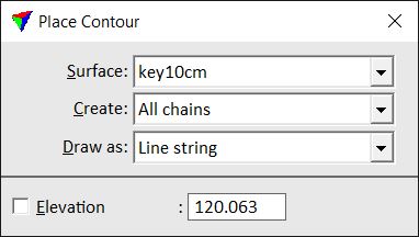
The Place Contour dialog opens:
2. Define settings.
3. Move the mouse inside a view.
A preview of the contour running at the mouse pointer location is dynamically displayed.
4. Confirm the contour with a data click.
This draws the contour(s) into the CAD file. You can continue with steps 2 or 3.
Setting |
Effect |
|---|---|
Surface |
Name of the effected surface model. |
Create |
Defines which contour lines are drawn: •Only one - only the contour line at the mouse pointer location is drawn. •All chains - all contour lines at the elevation of the mouse pointer location are drawn. |
Draw as |
Element type of the contour lines: •Curves - smooth elements for which the software computes the curvature, compact elements. •Line strings - sharp elements, suitable for preview. |
Elevation |
If on, contours are drawn at the given elevation. |