

TerraModeler User Guide
Label Profile Elevations
Not Spatix
 Label Profile Elevations tool labels a profile with elevation values. The tool can label a linear element drawn in the profile or single points identified with data points in the profile.
This tool can be used, for example, with an element representing a vertical alignment that has been designed in the profile. The element has to be linear. It should not extend beyond the profile's left or right margin. The tool translates the y-coordinates of the element into elevation values and writes these values below the profile.
The font, size, and number settings for the labels can be defined in Profiles / Labels category of TerraModeler Settings. The symbology of the labels is determined by the active symbology settings in the CAD file.
To label a profile with elevations:
1. Select the Label Profile Elevations tool.
This opens the Label Profile Elevations dialog:
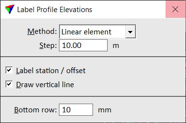
2. Define settings in the dialog.
3. Identify the profile to label.
Continue according to the selected Method.
Method: Linear element
4. Identify a linear element to be labeled.
5. Accept the element.
The element's elevations are labeled. You can continue with step 4.
Method: Single location
4. Move the mouse pointer inside the profile area.
The elevation at the mouse pointer location is displayed.
5. Enter a data point in order to draw the label into the CAD file.
You can continue with step 5.
Setting |
Effect |
|---|---|
Method |
Labeling method: •Linear element - labels elevations of a linear element at fixed Steps. •Single location - labels the elevation of a single data point. |
Label station / offset |
If on, the station value (profiles) or the offset from an alignment (cross sections) is drawn for each elevation. For station values the labeling relies on the settings for bottom row contents defined in Profiles / Layouts category of the TerraModeler Settings. |
Draw vertical line |
If on, a vertical line is drawn at each elevation label location. |
Bottom row |
Distance between the lower boundary of the profile’s elevation range and the line of elevation labels. Given as millimeters on paper. |
The Label Profile Elevations tool works only as long as the alignment element for a profile is drawn in the CAD file. Once the alignment element is deleted, labeling profile elevations is no longer possible.