

TerraModeler User Guide
Export / Lattice file
Not Lite
Lattice file command creates a lattice model file from a surface model. Lattice models are representations of a surface using a grid structure of points. The lattice model files include regularly distributed points at constant intervals in both, X and Y directions. Common storage formats are text files, image files, or software-specific grid file formats.
The command can create lattice files for multiple selected rectangles in a batch process. This requires rectangles drawn in the CAD file that define the lattice file boundaries. In order to automate the file naming for the output files as well, a text element can be placed inside the rectangles. Both, the rectangles and the text elements must be selected in order to use them in the export process.
To create lattice model file(s) from a surface model:
1. (Optional) Draw and select rectangle(s) and text element(s) for defining the area of the output file(s).
2. Select Lattice file command from the File / Export pulldown menu.
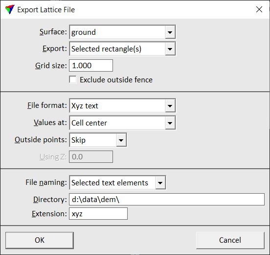
This opens the Export Lattice File dialog:
3. Define settings and click OK.
4. If the area of the output file is not selected in step 1, define the export area by drawing a rectangle with two data clicks in a top view.
5. If the output file names are not defined by selected text elements, the Export grid file dialog opens, a standard dialog for saving file.
6. Enter a name including the file extension for the output file and click OK.
The lattice file is created.
Setting |
Effect |
|---|---|
Surface |
Surface model for which to create the lattice file. |
Export |
Area covered by the output file: •Whole surface - the complete surface model is exported. •Rectangle - the surface model area for export is defined by a orthonormal rectangle. •Rotated rectangle - the surface model area for export is defined by a rotated rectangle. This is only active if File format is set to Intergraph GRD. •Selected rectangle(s) - the area defined by selected rectangle(s) is exported. This is only active if at least one rectangular shape is selected. |
Grid size |
Constant distance between points in the grid structure of the lattice model file. |
Exclude outside fence |
If on, the surface points outside a selected polygon or fence are treated as outside points. |
File format |
Format of the output file. Available formats are: •ArcInfo Grid, Intergraph GRD •Disimap raster format •GeoTIFF formats, Shaded GeoTIFF •Japanese DMF and LEM •Raw image formats •Surfer ASCII and binary •XYZ text Many of the additional settings for the lattice files depend on the selected format for the output files. |
Values at |
Defines the exact location of the lattice point coordinates: •Cell center - the coordinates of the grid cell center are stored. •Cell corner - the coordinates of the grid cell corner are stored. For some output file formats only one option is available. |
No data value |
Defines a constant value for grid cells inside the lattice model area where no elevation value can be derived from the source data. This can be, for example, a software-specific value. |
Z unit |
Defines the elevation value unit for several raster formats. |
Create TFW files |
If on, external georeferencing files are created for GeoTIFFs . |
Write coordinate block |
If on, positional information is written into the structure of Intergraph GRD files. |
Byte order |
Defines the byte order for Raw image formats related to the processor type: Intel or Motorola. |
Outside points |
Defines for Xyz text files how to handle grid points outside the lattice model area where no elevation value can be derived from the source data: •Skip - outside grid points are not written into the text file. •Output - outside grid points are written into the text file using the constant value given in the Using Z field. |
File naming |
Defines the file naming method if several output files are created: •Enter name for each - the software asks you to enter a name for each lattice file that is created. •Selected text elements - the software uses a text element placed and selected inside the rectangle(s) as file name. This is only active if Export is set to Selected rectangle(s). |
Directory |
Directory for storing the output file(s). This is only active if File naming is set to Selected text elements. |
Extension |
File extension for the output file(s). This is only active if File naming is set to Selected text elements. |