

TerraScan User Guide
Write Alignment Elevations
 Write Alignment Elevations tool writes elevation values derived from point cloud data along an alignment. The process is based on the selection of two alignments, one defines the alignment for which to write elevation values, the other provides the stationing. The first alignment element can be, for example, a line that runs along a part of a road and is located on a lane, the second alignment element could be the centerline of the whole road. However, both alignments can also be derived from the same vector element.
The software fits a plane equation to the laser points at regular steps along the alignment and derives an elevation value. The values are written into a report. Supported report formats are S X Y Z (Station, Easting, Northing, Elevation) and ERD. The ERD file format can be read into ProVAL, a software for road profile analysis.
To write elevations along an alignment:
1. Select Write Alignment Elevations tool.
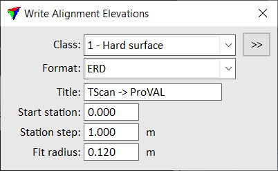
This opens the Write Alignment Elevations dialog:
2. Define settings.
3. Select the first alignment element for which you want to write elevation values. You can select the element by placing a data click close to it.
4. Select the second alignment element from which you want to derive the stationing. You can select the element by placing a data click close to it.
This derives the elevation values and opens the Alignment elevations window, a TerraScan report window.
You can save the report as text file or send it directly to a printer by using corresponding commands from the File pulldown menu of the report window. The size of the report window can be adjusted by commands from the View pulldown menu.
SETTING |
EFFECT |
|---|---|
Class |
Point class(es) from which the elevation values are derived. |
|
Opens the Select classes dialog which contains the list of active classes in TerraScan. You can select multiple source classes from the list that are then used in the Class field. |
Format |
Report format: •S X Y Z - Station Easting Northing Elevation •ERD - ERD file format including a header and the elevation values. |
Title |
Text used as title in an ERD file. This is active only if Format is set to ERD. |
Start station |
Station value of the first station along the alignment. |
Station step |
Interval size for deriving elevation values. |
Fit radius |
Radius around each station within which the points are used to compute the elevation value. |
