

TerraPhoto User Guide
Define Coordinate Setup
 Define Coordinate Setup tool sets up coordinate system values that a Terra Application uses for laser points and images. It determines the coordinate range inside which all data must be located and the resolution to which coordinate values are rounded. The coordinate setup is stored into the active CAD file and is used by all Terra Applications.
Terra Applications use signed 32 bit integer values for storing coordinates of laser points and images. This has the advantage of using only 12 bytes of memory for the coordinate information of each point. You can control how accurately coordinate values are stored by defining how big each integer step is.
If, for example, one integer step is equal to one millimeter, all coordinate values are rounded to the closest millimeter. At the same time it would impose a limitation on how far apart points can be or how big the coordinate ranges are. Millimeter steps produce a coordinate cube which has a size of 232 millimeters or 4294967.296 meters. If the origin of the coordinate system is at [0.0, 0.0, 0.0], the coordinate ranges are limited to values between -2147483 and +2147483. If necessary, you can fit the coordinate ranges to your data by modifying the Easting and Northing coordinates of the coordinate system origin.
If one integer step is equal to one centimeter, the coordinate values can range from -21 million to +21 million which is large enough for most coordinate systems.
To define the coordinate setup:
1. Select the Define Coordinate Setup tool.
This opens the Define Coordinate Setup dialog:
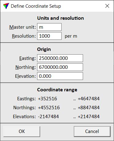
2. Define settings and click OK.
This modifies the coordinate system values used by all Terra Applications in the active CAD file.