

TerraPhoto User Guide
Fields
Fields command lets you select which attribute columns are displayed for each attached image in the Manage Raster References window.
To select visible fields:
1. Select Fields command from the View pulldown menu.
This opens the View Reference Fields dialog:
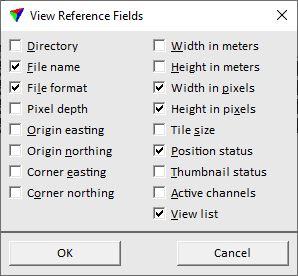
2. Select the fields you want to display and click OK.
SETTING |
EFFECT |
|---|---|
Directory |
Directory where the reference image is stored. |
File name |
File name of the reference image. |
File format |
File format of the reference image. |
Pixel depth |
Pixel depth of the reference image. |
Origin easting/northing |
Coordinate values of the image origin. |
Corner easting/northing |
Coordinate values of image corner opposite to the origin. |
Width/Height in meters |
Image width and height in meters. |
Width/Height in pixels |
Image width and height in pixels. |
Tile size |
Shows the size of tiles, if the image is a tiled image file. |
Position status |
Indicates, if the position of the image is defined: •OK - positional information for the image is available. •Undefined - no positional information is available for the image. •Outside - the position is outside the coordinate range defined for the CAD file. |
Thumbnail status |
Indicates, if thumbnails are available: •OK - thumbnails are available. •No - thumbnails are not available. |
Active channels |
Numbers of active channels of the reference image. |
View list |
View numbers for which the display of the image is switched on. |