

TerraPhoto User Guide
Import Drone Mission
Not Lite
Import Drone Mission command imports data that has been collected with UAV-mounted systems and pre-processed with system-specific software. The input data includes the raw images and their orientation information, the camera calibration and optionally, trajectory information. The command creates TerraPhoto UAV mission, camera and image list files, and optionally, converts the trajectory information into the TerraPhoto trajectory format. In addition, the input data may be transformed into the target projection system and a geoid correction may be applied to trajectory information.
The import of input data may be system-specific due to file and metadata formats.
To import a UAV survey mission:
1. Select Import Drone Mission command from the Wizard menu.
This opens the New Drone Mission dialog:
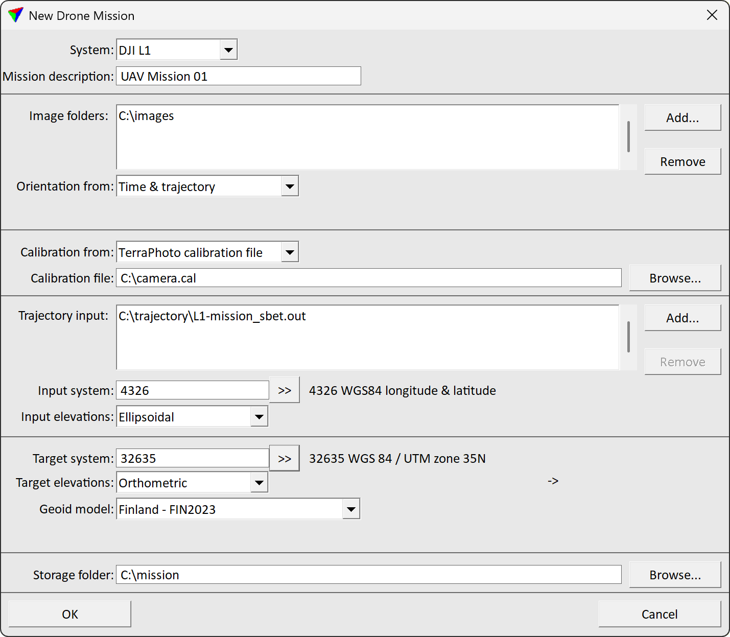
2. Define settings and click OK.
SETTING |
EFFECT |
|---|---|
System |
System used to capture the data: •DJI L1 - DJI ZENMUSETM L1 system. •DJI L2 - DJI ZENMUSETM L2 system. •DJI P1 - DJI ZENMUSETM P1 system. •Other - any other UAV system. |
Mission description |
Descriptive text for the new mission. |
Image folders |
Folder(s) storing the raw image files. Use the Browse button to open a standard dialog for selecting a folder. |
Orientation from |
Defines how the image orientation is derived: •Time & trajectory - position and orientation values from trajectory information is used. The time stamp determines when an image was captured an thus, enables the link from an image to the correct trajectory position. •Blocks exchange file - information from an external exchange file is used. •Image metadata - the information is read from the image metadata. |
Exchange file |
Defines the exchange file. Use the Browse button to open a standard dialog for selecting a file. This is only active if Orientation from is set to Blocks exchange file. |
Calibration from |
Defines how the camera calibration is derived: •TerraPhoto calibration file - a previously created TerraPhoto camera calibration file is used. •Blocks exchange file - information from an external exchange file is used. •Image metadata - the information is read from the image metadata. |
Calibration file |
Defines the camera calibration file. Use the Browse button to open a standard dialog for selecting a file. This is only active if Calibration from is set to Calibration file. |
Exchange file |
Defines the exchange file. Use the Browse button to open a standard dialog for selecting a file. This is only active if Calibration from is set to Blocks exchange file. |
Trajectory input |
Raw trajectory data provided by the system-specific software. Click on the Add button in order to select the input files in a standard dialog. The expected format of the trajectory information is SBET.OUT for the DJI L1 system. This is only active if Orientation from is set to Time & trajectory. |
Input system |
Projection system of the raw trajectory. Projection systems are defined by their EPSG code. See more information about projection system definition in Coordinate transformations / Transformations. This is only active if Orientation from is set to Time & trajectory. |
Input elevation |
Elevation system used for the raw trajectory: Ellipsoidal or Orthometic. This is only active if Orientation from is set to Time & trajectory. |
Target system |
Projection system for processing the data. Projection systems are defined by their EPSG code. See more information about projection system definition in Coordinate transformations / Transformations. |
Target elevations |
Elevation system used for processing the data: Orthometric or Ellipsoidal. |
Geoid model |
Geoid model for adjusting elevation values from ellipsoidal to orthometric system or vice versa: •Points from file - text file with X Y dZ values. •<implemented model> - name of an implemented geoid model. |
Storage folder |
Location for storing the data related to the misson. Click on the Browse button in order to select a folder in a standard dialog. |