Creating a Surface Model
TerraModeler provides a number of tools for surface model creation. The source data may be different as well as the first steps of the creation workflow. They are described for the individual tools. At some point, the workflow becomes the same for all tools. The steps described here are the same for all model creation processes.
To continue creating a surface model:
1. Follow the steps for the individual tools to start the surface model creation.
After the tool-specific steps, the Triangulate surface dialog opens:
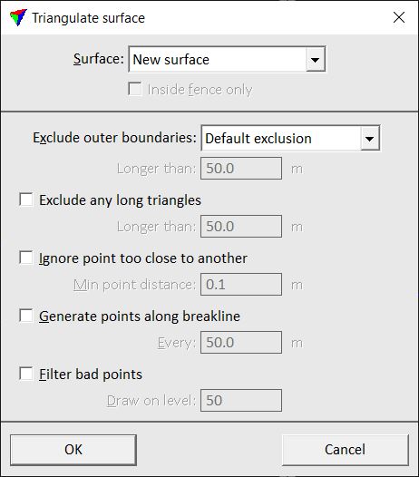
2. Select the surface to be triangulated. You can select a new surface or an existing surface that is loaded in TerraModeler.
3. If required, select additional settings for excluding triangles and point handling.
4. Click OK.
Setting |
Effect |
|---|---|
Surface |
Determines how the surface is created: •New surface - a new surface is created. •<surface name> - new features are added to an existing surface model that is loaded in TerraModeler. |
Create as profile model |
If on, the surface is created from a centerline element. TerraModeler internally copies the element to the left and right, and uses these elements for surface creation. |
Exclude outer boundaries |
Exclusion method of outer boundary triangles of the surface model: •No exclusion - no triangles are excluded. •Default exclusion - the software computes a reasonable triangle length for exclusion from the surface’s point density. •By key-in length - triangles with edge lengths given in the subsequent Longer than field are excluded. |
Exclude any long triangles |
If on, any triangles with edge lengths longer than the value given in the subsequent Longer than field are excluded. |
Ignore point too close to another |
If on, the model is thinned by leaving out unnecessary points. If the distance between two points is less than Minimum point distance, one of the points is left out. |
Generate points along breakline |
If on, the model is improved by generating new points along any long breaklines. Points are generated at a distance given in the Every field. |
Filter error points |
If on, probable survey errors are filtered out from the model. Points that have been filtered out are drawn as small circles on the level defined in the Draw on level field. |
If a new surface is created, the software opens the Surface Settings dialog:
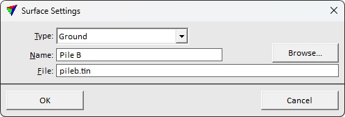
5. Select a surface Type and type a Name for the surface.
6. (Optional) Rename the File for storing the model on the hard disk. Browse storage destination for saving the model.
7. Click OK.
TerraModeler creates the surface model. A progress bar shows the process. After the process is finished, the time needed for the creation process is displayed in the status bar of the CAD platform.