By absolute elevation
Not Lite
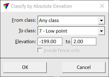
By absolute elevation routine classifies points within a given elevation range. It uses the elevation values stored for laser points in order to decide which points are classified. This can be used to classify error points high up in the air or clearly below the ground level.
SETTING |
EFFECT |
|---|---|
From class |
Source class(es). |
To class |
Target class. |
Elevation |
Elevation range within which points are classified. Given in absolute elevation values. |
Inside fence only |
If on, points inside a fence or selected polygon(s) are classified. |