

TerraScan User Guide
Water surface
Water surface routine classifies water surface points from bathymetric data. The routine suits for cleaning water surface points to a separate class, to avoid interference in water bottom classification. The routine expects open sky above the water surface, and points appearing below the water surface.
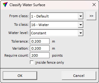
SETTING |
EFFECT |
|---|---|
From class |
Source class(es). The source classes must contain the water surface and the bottom. |
|
Opens the Select classes dialog which contains the list of active classes in TerraScan. You can select multiple source classes from the list that are then used in the Ground, Roof or Vegetation fields. |
To class |
Target class. |
Water level |
Complexity of the water surface: •Constant - the water level does not change across the area. •Vary by group - the water level varies by location, for example, due to heavy current. |
Tolerance |
Offset from the main surface allowed in surface detection. Should correspond to the measurement noise from the water surface. |
Variation |
Variation of the water surface elevation. Use higher value on environments with changing surface level, like rivers. |
Require count |
Minimum point count that is needed to define a water body. |
Inside fence only |
If on, points inside a fence or selected polygon(s) are classified. |
