

TerraModeler User Guide
Import / Lattice file
Not Lite
Lattice file command imports lattice files and create a triangulated surface model using the grid-based points. Accepted lattice file formats are ArcInfo Grid, Intergraph GRD, Finnish National Land Survey Disimp grid files and Ordnance Survey NTF grid files.
To import a lattice file:
1. Select Lattice file command from the File / Import pulldown menu.
This opens the Import grid file dialog, a standard dialog for opening files.
2. Locate the file that stores the surface model points.
This opens the Import Lattice File dialog:
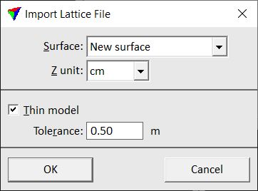
3. Define settings and click OK.
This opens the Surface settings dialog. Continue as described for File / New surface command.
A new surface model is created from the lattice file.
Setting |
Effect |
|---|---|
Surface |
Surface to be created from the lattice file. Always New surface. |
Z unit |
Unit of the elevation values in the lattice file. |
Thin model |
If on, the software leaves out less relevant points from the lattice file in order to reduce the file size of the surface model file. |
Tolerance |
Elevation tolerance for creating the model from the original lattice file. The surface model may differ in elevation up to the given value from the original. This is only active if Thin model is switched on. |
A triangulated surface model requires a lot more memory than a lattice model file, if all the lattice points are used in the triangulation. Therefore, it might be necessary to leave out some of the lattice points. TerraModeler is capable of leaving out less relevant points and still building a triangulated network within a given tolerance of the original grid points.