

TerraMatch User Guide
Measure Match
 Measure Match tool measures how well different strips match each other. It computes the elevation difference between surfaces from individual strips and a mean surface.
The report value can be used to determine if laser strips are matching each other better or worse compared to an earlier measurement. You can use this tool:
•Determine if strips match each other at normal level (comparing to earlier projects).
•Determine if a modification applied to laser data was an improvement (comparing before and after modification).
As the comparison is based on surfaces, you should normally perform ground classification on each strip individually before running this tool. You may also classify some other suitable surfaces such as building roofs from each strip.
Measure Match tool can use all the points from laser data files in a TerraScan project or loaded points.
To measure how well strips match:
1. Select the Measure Match tool.
This opens the Measure Match dialog:
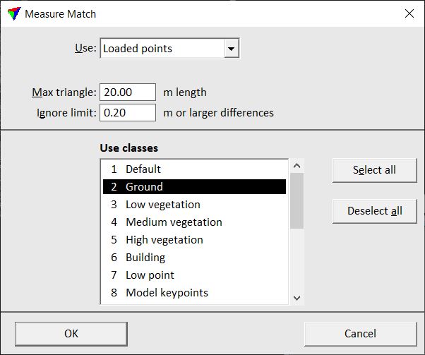
2. Select rows in the list box for the classes to use in the comparison.
3. Define the other settings and click OK.
The application computes the average elevation differences between each strip and a mean surface.
Setting |
Effect |
|---|---|
Use |
Data to use for comparison: •Project points - all blocks referenced by a given project file. (not UAV) •Loaded points - points loaded into TerraScan. |
Laser project |
TerraScan project file to apply corrections to. This is only active if Apply to is set to Project points. |
Max Triangle |
Maximum length of a triangle created for the surface-to-surface comparison. |
Ignore limit |
Limit value for differences between strips that the software uses for computing elevation differences. Larger mismatches are treated as gross errors and therefore not included in the calculation. |
Use classes |
Classes to use for computing elevation differences between individual strips and the mean surface. |
The results are shown in the Measure Match report:
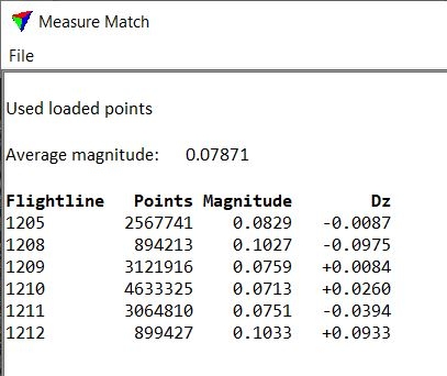
Attribute |
Meaning |
|---|---|
Average magnitude |
Mean value of absolute elevation difference values. |
Flightline |
Number of the line. |
Points |
Amount of points included in the computation for each line. |
Magnitude |
Absolute value of the elevation difference between a line and the mean surface. |
Dz |
Mean value of the elevation difference between a line and the mean surface. |